Interested in Hiking the trail?
Hiking in new places can be intimidating. Here's some resources to help you learn more.
UintaHighlineTraill.com New website with all sorts of Uinta Highline Trail Info.
Excellent and thorough guide book on the Uinta Mountains by author Cordell Andersen
Blog/trail guide by Paul Mags that we used to help plan the trip.
9 part youtube series by Redbeard about the trail
GPS files we used Updated to include better water sources!!
Recommended Maps: West Side of Highline Trail and East Side of Highline Trail
Shuttle service AND resupply service : https://mountain-trails-transport.business.site Tell them Outmersive sent you!
Best hotel in Vernal Dino Inn and Suites. (Run by super nice people, and they serve great breakfast too.
Contact info for more info and current conditions:
Duchesne/Roosevelt Ranger District (435) 738-2482
PO Box 981
85 West Main St. Duchesne, UT 84021
Heber/Kamas Ranger District (435) 783-4338
PO Box 68
50 East Center Street Kamas, UT 84036
Evanston/Mountain View Ranger District
(307) 789-3194/ (307) 782-6555
PO Box 1880
1565 Highway 150 South #A
Evanston, WY 82931

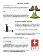
Things You Must Know Before Attempting The Highline

The Uinta Highline Trail is a beautiful and worthwhile adventure, however it's much more rugged and remote than trails like the John Muir Trail. Our cast and crew were composed of VERY experienced backpackers. We also did a substantial amount of research including contacting locals who knew the area. Even still, we had challenges that you should be aware of before attempting this journey.
Water
Water is scarce the first 20 miles from the East (Starting at hwy 191).
We had information from a local about small springs just off the trail (see GPS tracks above). We also had backup plans to venture further off trail to East Park Reservoir and Oak Park Reservoir in case the springs were dry. The small springs worked out, however water quality was questionable due to local cow activity. Filtering is essential. Luckily, high quality water is plentiful on the remaining western 80 mile section of the trail.
Navigation is a challenge
Many points on the trail, there is no trail. You are hiking from rock cairn to rock cairn, or following blazes on the trees. We found ourselves lost several times, especially on the eastern section. So GPS, a map and compass are highly advised.
Altitude sickness is more likely due to the elevation profile.
On the John Muir Trail, you climb as high as 14,505ft. On the Uinta Highline Trail, you peak at only 13,534ft. So its easier right? WRONG. We learned that the hard way. Trails like the JMT take you high, but you usually take a few days to get there, and you sleep below 9K ft. Most of the Highline Trail never drops below 10K ft. This had a profound effect on our group. 2 of our most experienced hikers experienced severe altitude sickness. Both had been at much higher elevations in the past. Be prepared, stay hydrated, take your time to acclimate to elevation by camping at the trailhead before you start. If you're sensitive to elevation, talk to your doctor before attempting this trail.
Lightning is frequent
We had some close calls with lightning. On the Highline most of the trail is high, and sometimes very exposed. Even in late Aug, we had lighting most days. Plan to camp low whenever possible, and hit passes earlier in the day when storms are less likely.
You are remote
On the Highline Trail, you will likely go several days at a time without seeing anyone. While the peaceful solitude is nice, it also means you're on your own if there's an emergency and bailout points are infrequent. There is virtually no cell service anywhere on the trail, so we HIGHLY recommend carrying a sat phone or GPS beacon device. Here's the one we used. But there's plenty of other options on the market.
Highline Trail Ethics and Safety
Highline Trail Ethics and Special Regulations
Highline Trail Ethics and Special Regulations
Highline Trail Ethics and Special Regulations
Highline Trail Ethics and Special Regulations
Highline Trail Ethics and Special Regulations
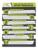
Leave No Trace Principles
Highline Trail Ethics and Special Regulations
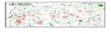
Highline Trail General Info Map
Highline Trail General Info Map
Highline Trail General Info Map
Highline Trail General Info Map
Highline Trail Safety 1
Highline Trail General Info Map
Highline Trail Safety 1
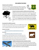
Highline Trail Safety 2
Highline Trail General Info Map
Highline Trail Safety 1